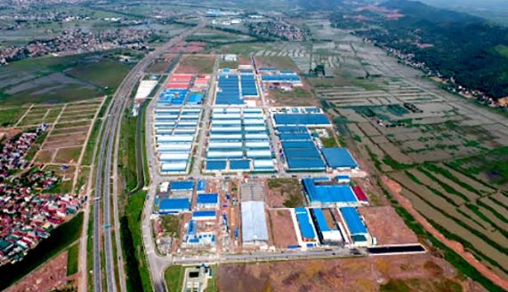
Bac Giang adjusts the planning of Quang Chau Industrial Park 516 ha
The People’s Committee of Bac Giang province has just approved the partial adjustment of the construction subdivision planning of Quang Chau Industrial Park, Viet Yen district (at the rate of 1/2000).
Specifically, adjusting the planning of 1.12 hectares of green land, water surface into traffic land, moving the drainage canal to the east, expanding the drainage canal into a lake.
Adjusting the planning of 0.58 ha of green land and water surface into administrative and service land; about 1.26 ha is used for parking lots and about 1.17 ha is used for transportation infrastructure.
In addition, 1.61 ha of parking lot land has been converted into industrial land; 1.63 ha of green land into administrative and service land; adjust 0.48 ha into current residential land and take it out of the boundary of the industrial zone planning.
Adjust the planning of 0.48 ha of administrative and service land to the current residential land and move it out of the planning boundary of the industrial zone.
At the same time, the province decided to expand the northwest border, bordering the Hanoi – Lang Son expressway with a width of about 2 m to ensure an industrial park area of 516 ha.
In terms of technical infrastructure, the northeast traffic section is adjusted to be adjacent to the T1 drainage canal, the cross section is from 22.5 m to 38.5 m and the cross section is 34 m wide.
Previously, Quang Chau Industrial Park was approved for adjustment and expansion in July 2021. The planning study area is about 516 hectares, of which the current area is about 426 hectares, the extension is about 90 hectares.
The North borders on agricultural land in Van Coc village, Van Trung commune. To the south, it borders Dong Tien and Nam Ngan villages, Quang Chau commune. The East borders Quang Bieu Pine, Quang Chau Commune and Trung Dong Village, Van Trung Commune. The West borders the Hanoi – Lang Son highway.
In addition to the above project, recently, the People’s Committee of Bac Giang province has also approved the detailed construction planning task of Lac Phu 2 urban area, Nham Bien town, Yen Dung district, scale 1/500.
Accordingly, the planning study area is located in the north of provincial road 398, within the boundary of Kem street, Nham Bien town.
The North borders the residential area of Kem street, Nham Bien mountain and the project of Khe Hang Dau eco-zone. The South borders National Highway 17. The West borders on rice fields and residential areas of Kem street. The East borders Lac Phu residential area 1.
The project scale is about 27 ha; the area of research, design and planning is about 23.95 ha. The population size is about 3,000 people.
Lac Phu 2 urban area, Nham Bien town is a new urban area associated with public works at the residential unit level.
The main items that need construction investment include: Technical infrastructure such as leveling ground, building traffic routes, parking lots, power supply system, lighting, water supply and drainage, technical sewers; public works, services such as schools, commercial – service works, parks, green campus – physical training and sports,…; housing projects such as semi-detached houses, villas, high-rise mixed houses.
By moitruongvadothi